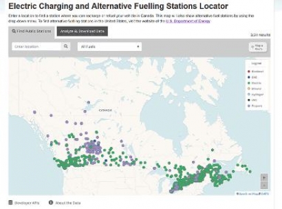
The Electric Charging and Alternative Fuelling Stations Locator is a Canadian version of NREL’s Alternative Fuelling Station Locator and utilises a screenshot of the map of Canada overlaid with multiple coloured dots to represent the locations of fuelling stations to alternatively fuelled vehicle drivers.
The development of the tool is a part of a significant investment by the Canadian government to expand Canada’s electric and alternative fuelling infrastructure. The data can be accessed using the tool’s ‘Analyse & Download Data’ function and located by searching geographic location, along a route, by public or private stations or by payment options.
The Canadian data is now also available via the open application programming interface on the NREL Developer Network. This means analysts and web developers anywhere can obtain accurate and trusted data about fuelling sites in both Canada and the US. The NREL-Canada partnership also signifies a first step in evaluating what capabilities exist for creating a single tool with station information across North America.
“This was an exciting and challenging project all around” said Senior Project Lead Rob Eger, who led the development effort on behalf of NREL. “Working with our partners at NRCan, we were able to develop a modern, bilingual web tool that makes it easier for drivers of alternative fuel vehicles to find credible information.”
NREL's Johanna Levene, who manages crosscutting Station Locator data programmes, added that the Canadian tool provides endless opportunities for building out other alternative fuel applications and analyses and that NREL is already investigating requirements for adding international alternative fuel corridors in the future.
For additional information:

