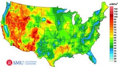
The three-year project, for which Google provided an unspecified amount of funds, was undertaken to update the geothermal map of North America compiled by researchers at Southern Methodist University in Dallas, Texas.
The study was conducted by SMU Geothermal Laboratory, led by principal Investigator Dr. David Blackwell, and incorporated tens of thousands of new Bottom Hole Temperature (BHT) readings from oil, gas, and water wells in previously under-sampled regions of the US to create the most data rich perspective on US geothermal resources to date.
The project estimates that Technical Potential for the continental US exceeds 2,980,295 megawatts using Enhanced Geothermal Systems (EGS) and other advanced geothermal technologies such as Low Temperature Hydrothermal.
Historically, geothermal development has been restricted to areas with substantial tectonic activity or volcanism, such as The Geysers field in California.
But sophisticated mapping of geothermal resources directed by Blackwell, SMU’s Hamilton professor of Geothermal Studies, and Maria Richards, director of SMU’s Geothermal Laboratory, makes it clear that vast geothermal resources reachable through current technology could replace and multiply the levels of energy currently produced in the United States - mostly by coal-fired power plants.
Three recent technological developments are feeding increased geothermal development in areas with little or no tectonic activity or volcanism:
•Low Temperature Hydrothermal – Energy is produced from subsurface areas with naturally occurring high fluid volumes at temperatures ranging from less than boiling to 300°F (150°C). This approach is producing energy in Alaska, Oregon, Idaho, and Utah.
•Geopressure and Coproduced Fluids Geothermal – Oil and/or natural gas are produced together with electricity generated from hot geothermal fluids drawn from the same well. Systems are installed or being installed in Wyoming, North Dakota, Utah, Louisiana, Mississippi and Texas.
•Enhanced Geothermal Systems (EGS) – Subsurface areas with low fluid content but high temperatures are “enhanced” with injection of fluid and other reservoir engineering techniques. EGS resources are typically deeper than hydrothermal resources and represent the largest share of total geothermal resources capable of supporting larger capacity power plants.
The national mapping project makes it possible to access reliable geothermal data (heat flow and temperature-at-depth information) culled from oil and gas development all over the country.
The mapping project already has determined that there is potential for more electric generation from geothermal sources in West Virginia than is currently being produced by the state's mostly coal-fired generation plants.
Even before SMU researchers completed their latest map, an assessment they produced for the Texas State Energy Conservation Office confirmed the existence of a vast, geothermal zone with enough heat to supply Texas with clean, renewable, affordable electricity for hundreds of years.
The new estimates are compliant with the new global geothermal mapping protocol developed by SMU, Hot Dry Rocks PTY, GeoWatt Ag, and Google.org which is now recognized by the International Energy Agency and the International Geothermal Association.
Under the protocol, Technical Potential is limited to depths of 3.5 to 6.5 km (6.5 to 10 km is considered “Theoretical Potential” under the protocol) and inaccessible zones such as national parks and protected lands are eliminated.
In addition to Blackwell and Richards, the research team included Zachary Frone, Joseph Batir, Ryan Dingwall, Andrés Ruzo, and Mitchell Williams.
For additional information:

