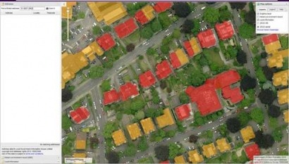
Produced in part by leading aerial survey specialist Blom, a map on this scale is the first of its kind in the UK, and was funded as part of a government grant. The map highlighting the solar potential of buildings on a backdrop of Blom imagery.
Nearly a quarter of a million buildings have been assessed, with a surprising third of these understood to be suitable to take advantage of the Government’s feed-in tariff scheme. It is hoped that it will encourage residents and businesses to invest into solar energy and further boost Bristol’s credentials as a leading ‘Green City’.
“This is another example of Bristol leading the way on the green agenda. Were the first local authority to produce a solar map, the first to be building our own wind turbines and the first local authority outside London to be setting up our own energy services company,” says Council Leader Barbara Janke. “The work we’ve done on the solar map pulls together a full picture of the city’s solar potential. Anyone who lives in Bristol who is thinking about the possibility of installing solar electric or hot water panels can use this map quickly and easily to find out whether it’s going to be viable for them.”
Blom have always enjoyed a successful working relationship with Bristol City Council, and have previously awarded them an Ordnance Survey ‘Innovation Award’ for the use and integration of Blom’s oblique aerial photography; BlomOBLIQUE.
“With the data now published the technology behind it has faced the first ‘acid test,’ and has been proven to work. Interestingly, it shows that the government’s previous methodology underestimated the solar potential of Bristol by approximately 75%. We’re keen to show councils across the UK just how much untapped potential there may be in their region and, with our recently captured off-the-shelf libraries, the proposition is more cost-effective than ever,” comments Andy Fleetwood, Business Development Executive for Blom UK.
For additional information:

