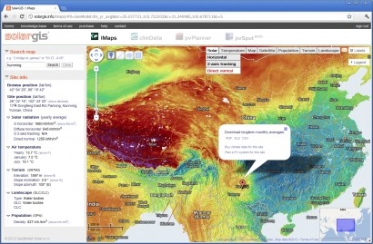
The interactive high-resolution map of Direct Normal Irradiation in China, forms part of the SolarGIS iMaps online tool and visualises China’s solar resource potential. The company says that the new state-of-the-art solar and meteo database, maps, and simulation tools will support “Feasibility, planning, and monitoring of photovoltaic power generation in China”.
During the recent SNEC 6th International Exhibition & Conference, one of the biggest solar exhibitions in the world, the Organising Committee acknowledged SolarGIS as “one of Top 10 Highlights” of the event.
"A lack of accurate solar resource data has been one of the major bottlenecks in the financing of solar energy projects [in China],” explains Amit Jain, who is an independent solar energy consultant. “The introduction of SolarGIS data in China will help to mitigate weather-related risk, associated with solar energy projects, and hence will reduce cost of financing."
The SolarGIS database features a unique set of qualities that have triggered new industry standards in terms of accuracy, efficiency and low uncertainty. SolarGIS confirms its position as the best solar resource database in several independent data comparison studies, and has been used in a number of commercial solar energy projects worldwide.
"Using high-resolution SolarGIS data allows an accurate solar energy yield prediction, which is crucial information for determining financial viability of each solar energy project", comments Marcel Suri, Managing director of GeoModel Solar and world leading expert in solar resource assessment and solar data bankability.
Solar power plant developers, engineers, installers, financers, policymakers and the wider community can access the SolarGIS database and iMaps and pvPlanner online assessment tools from the web-based platform.
[Inset: Map showing Direct Normal Irradiation in China]
For additional information:

