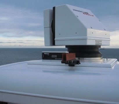
The launch is the latest Offshore Wind Accelerator (OWA) project designed to help reduce the cost of energy generated by offshore wind. Over the next three months the most comprehensive test of scanning LIDAR will take place, involving four different scanning LIDAR systems alongside three vertical profiling LIDARs for validation purposes. The project is supported by independent renewable energy company RES and the maritime safety organisation, Commissioners of Irish Lights.
Accurate wind resource measurements are critical to wind farm development because they are used to calculate the potential energy yield from a wind farm, thus dictating the terms of the project financing. This can be a significant proportion of the overall project cost, accounting for around 45 percent for an average wind farm.
Scanning LIDAR is not a new technology, as it is used by the defence and aerospace industries to monitor oncoming weather fronts. However, it does not yet have a proven track record in offshore wind.
Normally, the available wind resource is measured by large steel towers called met masts. These require a large capital investment, usually £10 million to £12 million, incurred at risk before a project gets the go-ahead. This in turn adds significant upfront cost to a project, thus inhibiting the exploration of new sites. The OWA project is aiming to test how accurately scanning LIDAR technology can measure wind resource for potential wind farm sites, thereby potentially delivering significant cost savings in the early stages of wind farm development.
OWA has been working for the past few years to support more cost effective solutions, focusing on the development and commercialisation of a number of floating LIDAR systems to significantly reduce upfront capital expenditure. However, measurements taken by both masts and floating LIDAR are limited in that they only provide a measurement of the wind resource at a single point in space. For an offshore wind farm covering an area of up to 200 square kilometres, this can create uncertainty on the wind speed at locations far from the measurement point. This is known as spatial variation, in which measurements taken may not be representative of the entire site. This is then translated into risk, incurring additional financing costs to wind farm development.
Scanning LIDAR technology could potentially reduce the risk associated with spatial variation in that such systems are capable of scanning with a usable range of 10-30 kilometres, delivering impressive levels of detail and taking over 100 measurements per minute. This allows developers to build a much more detailed picture of a site, significantly reducing spatial variation and allowing developers to plan the layouts of turbines more effectively, thus improving the exploitation of individual wind conditions at the site. This in turn could reduce risk to minimal levels, saving millions of pounds on a project and reducing the cost of energy from offshore wind.
Given that a difference of only 0.2 mph in wind speed can result in significant variation of yield calculations over the lifetime of a wind farm, it is critical that the industry has confidence in scanning LIDAR devices with regard to their ability to detect such small variations.
The OWA trial is aiming to test this sensitivity and will do so using 3 Leosphere WINDCUBE vertical profiling LIDARS, 1 Leosphere WINDCUBE 400S scanning LIDAR, 1 Leosphere prototype scanning LIDAR and 2 Lockheed Martin WindTracer scanning LIDARs.
“Many factors can impact available wind resource at a potential wind farm site including its proximity to shore, neighbouring wind farms, and as a result of tidal currents” said Megan Smith, Project Manager, Wakes Research at the Carbon Trust. “This project forms a really important stage of the OWA’s efforts to increase the industry’s understanding of wind resource measurement and validate the technologies capable of delivering results. Project financing is a significant proportion of cost, so anything we can do to get a deeper understanding of yield will increase investor confidence and lower the cost of financing. Scanning LIDAR has the potential to take our understanding to a completely new level. In information terms it is the difference between taking a still photo compared to having a three dimensional video with full sound. The need to test the sensitivity of the technology is the next frontier in getting industry acceptance.”
Ms Smith added that the ambitious project is relying on a range of key partners, including RES, Irish Lights and the technology developers Leosphere and Lockheed Martin, in order to get it successfully off the ground. The results will be shared with the wider industry in due course.
For additional information:

