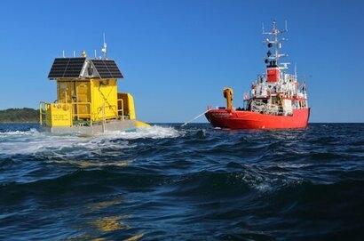
The Floating LiDAR systems will provide data to pave the way for the strategic development of floating offshore wind (FLOW) in the Celtic Sea, which the Crown Estate has earmarked for up to 4 GW of new clean energy capacity by 2035.
The project is being led by Hayle-based Celtic Sea Power under the £6 million Cornwall FLOW Accelerator program (part-funded by the European Regional Development Fund) which is working to speed up the development of FLOW in the UK and optimise its benefits for the region.
The WINDSEA floating LiDAR (Floating Laser imaging, Detection and Range) systems, provided by French company Akrocean, have been positioned around 60 miles offshore and use laser technology to accurately measure wind speeds and direction. Additional meteorological and oceanographic data will also be collected.
The buoys, which are 5.1 metres high and 2.4 metres wide, were deployed earlier this week out of Falmouth by specialist marine contractors Keynvor MorLift Ltd. They are expected to remain offshore for one year.
The valuable data will build an accurate picture of the wind profile out to sea and form a broad-scale wind resource model that will benefit the region.
“The data from these Floating LiDAR systems will benefit Cornwall, South Wales and the wider South West by feeding into a bank grade regional wind resource model” said Neil Farrington, Strategic Offshore Development Manager at Celtic Sea Power. “This model will then be validated by external experts (at Wood Group) to support investment decisions for FLOW sites across the UK Celtic Sea region. It will also help reduce the time it takes to install floating offshore wind farms”.
Celtic Sea Power estimates that having 3 GW of capacity installed or under development in the Celtic Sea by 2030 would create at least 1,500 primary jobs, around 9,600 broader jobs, and £900 million of net additional GVA, positioning the UK as a world-leader. It says some 20 offshore wind energy developers are interested in the Celtic Sea as a location.
Collaborative work with floating wind developers in the area will also enable access to other floating LiDAR data sets from deployments in the region. This principal of data sharing will provide additional validation of the regional wind resource model and help accelerate development to the benefit of the South West and Wales.
The acquisition of these new data sets and evolution of a bank-grade regional wind resource model could provide a number of benefits to the Celtic Sea FLOW sector. These include but are not limited to:
Helping to influence accelerated future leasing rounds and spatial allocations within regional planning policies by providing new data and evidence on the available wind resource and other metocean conditions, including waves and currents.
Driving wide acceptance of the real potential of the wind resource available in the Celtic Sea and the benefits this could provide in relation to national renewable energy targets.
De-risking early investment decisions.
Decreasing the cost of capital available to the FLOW sector by increasing confidence in resource modelling and generation projections.
Potentially negating the need for individual commercial developers to complete their own independent wind resource campaigns, saving a year in the project development process and significant expense.
Supporting individual developer resource campaigns (if necessary) by using the floating LiDAR deployments as an offshore validation point, reducing the current standard practice of requiring an on-shore MET mast for validation.
Reducing the embodied green-house gases consumed in delivering multiple wind resource campaigns across the Celtic Sea by maximising the joined-up value of more limited deployment numbers.
Helping, as part of a broader zonal planning approach to offshore wind farm development, to reduce the cumulative impact that offshore wind farm installations have on the marine habitats.
For additional information:

